If you are planning to use a Radio Lab jeep, you first must get to the UC Berkeley campus. To do this, you have two choices:Limo or Taxi
Once at the Downtown Berkeley BART station, for 25 cents you can ride a UC Berkeley shuttle bus to Campbell Hall (Hearst Mining Circle), saving you from lugging your stuff up the hill. You can get on the shuttle bus at the Bank of America across from the BART station.- From Oakland (OAK) or San Francisco (SFO) Airports, you can take a BayPorter Express shuttle for about $20. A taxi from SFO is $50+, from OAK is $30+.
Public Transportation (Bay Area Rapid Transit)
- From OAK, take Air-BART shuttle to the Coliseum/Oakland Airport BART station, then BART to Downtown Berkeley Station.
- From SFO, take the SamTrans bus to the Colma or Daly City BART stations, then BART to Downtown Berkeley Station. (SFO to Colma is an express route.)
In the table below are driving directions to Hat Creek Radio Observatory from the University of California, Berkeley campus. They use the so-called "short cut" through Manton. To see a detail map of any step, follow its
Show me link. The total distance is 265 miles; total driving time is 4.5 to 5 hours. If you do not wish to take the short cut which requires many turns, you take one of two alternate, longer routes through Redding.After a snowfall, Rte. 299 is more likely to be open than Rte. 44-- call for conditions or check the following web sites. If Rte. 44 is closed, you must take the long way via Rte. 299.
We have prepared an overview map of Northern California with all three routes highlighted (GIF format) and a higher quality map of the entire state with no highlighting (PDF format; requires free Adobe Acrobat). Also available is a map of the Hat Creek site.
| Direction | Stay on this road for | Map |
| Drive out the East Gate of campus. | Show me | |
| Left on Gayley Rd. | 1 block | Show me |
| Left at first traffic light on Hearst Avenue. | 5 blocks | Show me |
| Left at second traffic light on Oxford Rd. | 2 blocks | Show me |
| Right on University Avenue (West). | 2.0 miles | Show me |
| Take the I-80 East/I-580 West ramp. | 0.8 miles | Show me |
| Merge onto I-80 E. Stay on I-80 where the freeways split in Albany. | 44.1 miles | Show me |
| Cross Carquinez Bridge on I-80 at Vallejo (toll: $2.00) | Show me | |
| Take the I-505 North exit towards Winters/Redding. | 0.8 miies | Show me |
| Merge onto I-505 North. | 33.5 miles | Show me |
| Merge onto I-5 North. | 97 miles | Show me |
| Take second Red Bluff exit, Rte 36 East./Rte 99 | 2.2 miles | Show me |
| Left on Rte 36 East. | 12.4 miles | Show me |
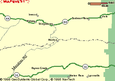
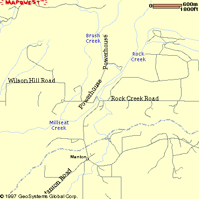
| Left on A6 (Manton Road) at Dales general store. | 15.6 miles | Show me |
| Left on Rock Creek Rd (aka Forward Rd). | 0.8 miles | Show me |
| Left on Wilson Hill Rd. | 7.3 miles | Show me |
| Right on Rte 44 at Shingletown, continuing past Lassen National Park. | 33.4 miles | Show me |
| Left on Rte 89 at Old Station. | 11 miles | Show me |
| Right on Doty Rd (watch for "University of California Radio Observatory" sign on right). | 1.4 miles | Show me |
| Right on Bidwell Rd -- if you get back to Rte 89 you've gone too far! There is now a sign at this intersection that reads "Hat Creek Observatory 1.8 miles" | 1.9 miles | Show me |
| Right into Hat Creek Radio Observatory entrance; key to gate is on the Jeep keychain. | ||
| Lab is straight ahead, dorm is to the right. |
There are two alternate routes through Redding, if you do not take the Red Bluff to Shingletown shortcut. Each of these add at least 1/2 hour to the drive.
If you get lost, the phone number for HCRO is (530) 335-2364.
And finally, a word about grocery shopping: