Slide 1
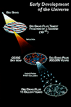
Early development of the Universe. The Cosmic Background Explorer (COBE) satellite was designed to measure the diffuse infrared and microwave radiation from the early Universe, to the limits set by our astrophysical environment.
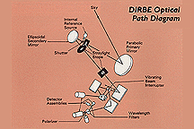
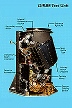
Slide 4 DIRBE optical concept showing mirrors, filters, detectors, and beam interrupter. The DIRBE uses an unobscured off-axis Gregorian telescope to collect light and bring it to a focus on 16 infrared detectors.
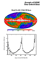
Slide 6 DIRBE scan track superposed on
100 µm Annual Average Map and 100 µm intensity from the corresponding
segment of time-ordered data. DIRBE
scanned the sky in a helical pattern
that resulted from the spin and orbital
motion of the COBE satellite and the
"look direction" of the telescope,
which was 30 degrees from the spin axis.
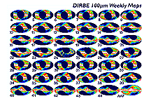
Slide 7 100 µm
Weekly Sky Maps for mission weeks
4 to 44, and the 100 µm
Annual Average Map. Shows sky coverage
each week of the DIRBE mission over
the period during which the COBE cryogen
supply lasted.
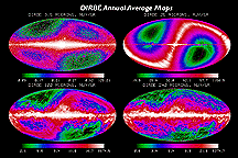
Slide 8
Annual Average Maps at 3.5, 25,
100, and 240 µm. Galactic coordinate
Mollweide projection maps of the entire
sky at four wavelengths showing emission
from stars and dust in the Galactic
plane (horizontal feature) and light
scattered and emitted by dust in the
solar system (S-shape).
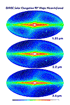
Slide 9 1.25, 2.2, and 3.5 µm
Solar elongation angle = 90 degree Maps.
Galactic coordinate Mollweide projection
maps of the entire sky as seen by the
DIRBE at a fixed angle relative to the
Sun. Stars concentrated in the Galactic
plane (horizontal feature) dominate
the images at these wavelengths.
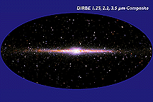
Slide 10 False-color image of the near-infrared
sky as seen by the DIRBE. Data at 1.25,
2.2, and 3.5 µm wavelengths are
represented respectively as blue, green
and red colors. The image is presented
in Galactic coordinates, with the plane
of the Milky Way Galaxy horizontal across
the middle and the Galactic center at
the center.
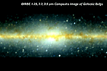
Slide 11 1.25, 2.2, 3.5 µm composite
image of Galactic center region. Shows
asymmetric shape of the bulge at the
center of the Milky Way. The image is
a Mollweide projection covering 60 degrees
in Galactic longitude by 20 degrees
in Galactic latitude and centered on
the Galactic center.
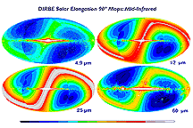
Slide 12 4.9, 12, 25, and 60 µm
Solar elongation angle = 90 degree Maps.
Thermal emission from star-heated dust
in the Milky Way and interplanetary
dust heated by the Sun dominates the
images at these wavelengths.
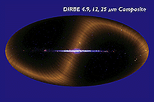
Slide 13 This image combines data from
the DIRBE obtained at infrared wavelengths
of 4.9, 12 and 25 µm. The sky
brightness at these wavelengths is represented
respectively by blue, green, and red
colors in the image.
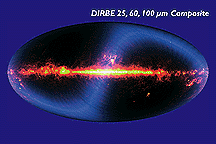
Slide 14 This image combines data from
the DIRBE obtained at infrared wavelengths
of 25, 60 and 100 µm. The sky
brightness at these wavelengths is represented
respectively by blue, green, and red
colors in the image. The plane of the
Milky Way Galaxy lies horizontally across
the middle of the image with the Galactic
center at the center.
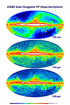
Slide 15 100, 140, and 240 µm
Solar elongation angle = 90 degree Maps.
Thermal emission from relatively cool
interstellar dust warmed by stars in
the Milky Way dominates at these wavelengths.
At high Galactic latitudes, interstellar
"cirrus" clouds are apparent.
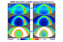
Slide 16 DIRBE 1.25 and 2.2 µm
maps of the sky as observed (top) and
following subtraction of a detailed
model of the zodiacal light (middle
and bottom), which at these wavelengths
is Sunlight scattered by interplanetary
dust grains.
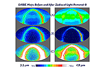
Slide 17 DIRBE 3.5 and 4.9 µm maps
of the sky as observed (top) and following
subtraction of a detailed model of the
zodiacal light (middle and bottom).
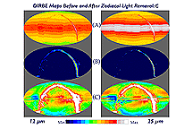
Slide 18 DIRBE 12 and 25 µm maps
of the sky as observed (top) and following
subtraction of a detailed model of the
zodiacal light (middle and bottom),
which at these wavelengths is thermal
emission from interplanetary dust grains
heated by absorbed Sunlight (see Kelsall
et al. 1998, ApJ, 508, 44).
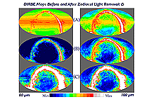
Slide 19
DIRBE 60 and 100 µm maps
of the sky as observed (top) and following
subtraction of a detailed model of the
zodiacal light (middle and bottom),
which at these wavelengths is thermal
emission from interplanetary dust grains
heated by absorbed Sunlight (see Kelsall
et al. 1998, ApJ, 508, 44).
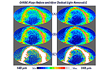
Slide 20
DIRBE 140 and 240 µm maps
of the sky as observed (top) and following
subtraction of a detailed model of the
zodiacal light (middle and bottom; see
Kelsall et al. 1998, ApJ, 508, 44).
Slide 21
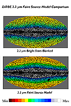
At near-infrared wavelengths, following the subtraction of zodiacal light (see Slide 16), map pixels containing discrete bright sources are masked and the DIRBE Faint Source Model is used to subtract residual Galactic starlight in order to detect or place an upper limit on the brightness of the cosmic infrared (extragalactic) background emission (Arendt et al. 1998, ApJ, 508, 74).
Slide 22
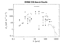
Results of the DIRBE search for the Cosmic Infrared Background (CIB) after removal of foreground emissions from the solar system and the Milky Way (see Hauser et al. 1998, ApJ, 508, 25).
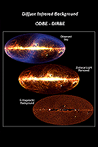
Slide 23 An illustration of the foreground emission subtraction process resulting in the DIRBE detection of the Cosmic Infrared Background at 240 µm. The map at the top is a false-color image showing the observed infrared sky brightness at wavelengths of 60 (blue), 100 (green) and 240 µm (red).
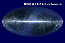
Slide 24 This image combines data from the DIRBE obtained at infrared wavelengths of 100, 140 and 240 µm - the longest wavelengths measured by this instrument. The sky brightness at these wavelengths is represented respectively by blue, green, and red colors in the image.
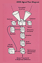
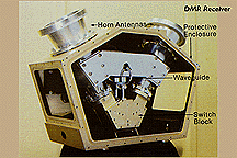
Slide 25 Signal flow in the DMR instrument, which was designed to detect and enable the characterization of temperature differences ("anisotropy") in the cosmic microwave background radiation. The DMR design is similar to that used in instruments flown on balloons and aircraft. The receiver input is connected alternately to two separate antennas that point at different parts of the sky.
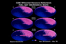
Slide 27 Early DMR sky maps depicting data obtained from the independent ("A" and "B") channels at each of the three observed microwave wavelengths: 3.3, 5.7 and 9.6 mm (corresponding frequencies are 90, 53 and 31.5 GHz, or thousand MHz, respectively).
Slide 28 Following subtraction of the dipole anisotropy and components of the detected emission arising from dust (thermal emission), hot gas (free-free emission), and charged particles interacting with magnetic fields (synchrotron emission) in the Milky Way Galaxy, the cosmic microwave background (CMB) anisotropy can be seen.
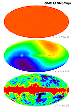
Slide 29 Maps based on 53 GHz (5.7 mm
wavelength) observations made with the
DMR over the entire 4-year mission (top)
on a scale from 0 - 4 K, showing the
near-uniformity of the CMB brightness,
(middle) on a scale intended
to enhance the contrast due to the dipole
described in the slide 19 caption, and
(bottom) following subtraction
of the dipole component. Emission from
the Milky Way Galaxy is evident in the
bottom image.
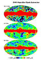
Slide 30 Maps based on observations made
with the DMR over the entire 4-year
mission, at each of the three measured
frequencies, following dipole subtraction.
See slide 19 caption for information
about map smoothing and projection.
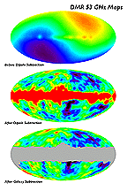
Slide 31 The 53 GHz DMR sky map (top)
prior to dipole subtraction, (middle)
after dipole subtraction, and (bottom)
after subtraction of a model of the
Galactic emission, based on data gathered
over the entire 4-year mission.
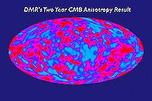
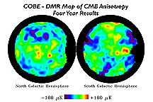
Slide 32 DMR "Map of the Early Universe."
This false-color image shows tiny variations
in the intensity of the cosmic microwave
background measured in four years of
observations by the Differential Microwave
Radiometers on NASA's Cosmic Background
Explorer (COBE).
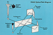
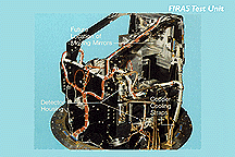
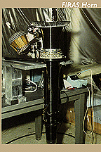
Slide 33 Concept of FIRAS, showing light
from the sky being focused through cone
and sent to interferometer. The FIRAS
instrument was designed to measure precisely
the spectrum of the cosmic microwave
background radiation over a wavelength
range from 0.1 to 10 mm.
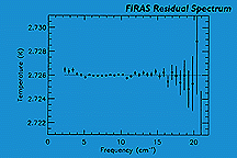
Slide 36
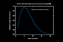
Cosmic microwave background (CMB)
spectrum. The solid curve shows the
expected intensity from a single temperature
blackbody spectrum, as predicted by
the hot
Big Bang theory.
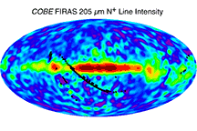
Slide 38 C+ 158 µm and N+ 205 µm line intensity maps from Fixsen et al. 1999, Astrophysical Journal, 526, 207,"COBE Far Infrared Absolute Spectrophotometer Observations of Galactic Lines" . The maps are projections of the full sky in Galactic coordinates. Note: The images from 1999 are based on combined destriped data with higher frequency resolution from the FIRAS Pass4 data release.
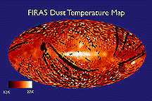
Slide 40 A map of the temperature of
interstellar dust in the Milky Way Galaxy
derived from FIRAS sub-millimeter data.
The map is a projection of the full
sky in Galactic coordinates. The plane
of the Milky Way is horizontal in the
middle of the map with the Galactic
center at the center.


